Opinion: DOT’s Delancey Street Median Plan Should Just Be the Start of Major Improvements
Last week, Sen. Kirsten Gillibrand and city officials announced plans for a “road diet” for Delancey Street on the Lower East Side. The thoroughfare has been dangerous for pedestrians for decades and is long overdue for a redesign to properly accommodate bikes and pedestrians.
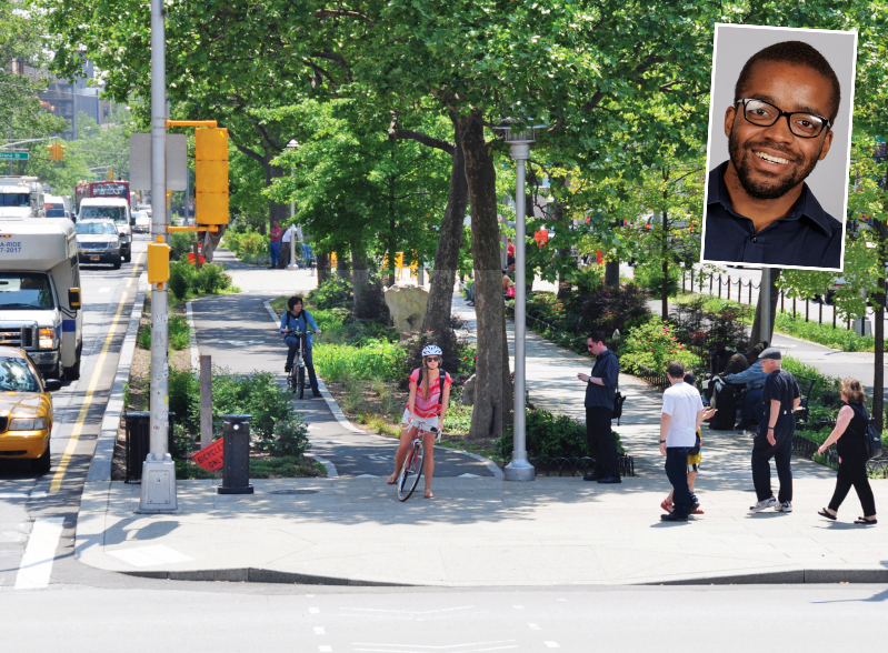
The specifics of Delancey Street’s transformation are unclear, but planners don’t have to look for what the redesign can look like. Intersecting Allen Street — which like Delancey has “malls” running down its median — sets a standard for what this kind of public space should look like: green space, public seating, safe bike lanes and room for pedestrians.
Allen Street has median malls south of Houston Street, medians that are accessible to pedestrians and park lovers alike. Thanks to the city’s transformation of the mall 10 years ago, cyclists also have safe access to the mall.
Allen Street is neither uniform nor perfect — the degree of protection for people biking varies, and the pedestrian paths range from winding painted cobblestone paths to a typical concrete sidewalk. But even at their most basic, the spruced-up malls provide New Yorkers a place to sit, relax, and walk underneath natural canopies created by the trees on each side of the path. And cyclists, including delivery workers, get a safe passage in and out of the Lower East Side.
These transformed malls also help from the perspective of green space. New York City has a problem with lackluster green space access. It’s not a complete solution for green space, but it is a small and impactful solution — and makes Allen Street a possible model for transformation across the city. Here’s where the city should look:
Broadway north of Columbus Circle
When most New Yorkers — and most people, period — think “Broadway” they think of the plethora of world-famous theaters bookending the thoroughfare and the nearby sidestreets, the sea of LED billboards stacked on top of each other around Times Square, and Macy’s. West Harlemites and Upper West Siders have a different answer: The five-mile-long mall at its center.
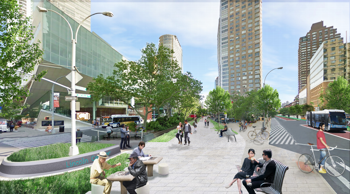
The 20-foot-wide Broadway Malls stretch from Columbus Circle to Mitchel Square, providing locals with 109 blocks of flora, the equivalent of approximately 10 acres of green space.
Unfortunately, West Siders can’t actually access the green space, outside of a few benches and a small pedestrian island at its intersections. The Broadway Malls function as a median, not a park splitting the six travel lanes on each side, and essentially the thoroughfare into a highway slicing through the Upper West Side, West Harlem, and Washington Heights — neighborhoods where less than 25 percent of residents own cars. The occasional bulb-outs and median buffers do little to reduce the dangerous consequences of these design choices.
But as Allen Street shows, it doesn’t have to be this way.
There is ample room for protected bike lanes at a minimum. The city should also more effectively protect these lanes, separating them with things like jersey barriers, bollards, or fences. Benches, tables, and chairs could be installed across the mall, providing space for people to eat and relax. In the middle would be the pedestrian path, lined with grass, trees, and flowers. On top of the flora, the city could add more art installations, like those that currently exist along the malls.
A transformation of this sort is not unheard of — once upon a time, Broadway’s malls were accessible to pedestrians, just like Allen Street. This past life only proves the feasibility of such a project like this. It could also become a catalyst for more holistic pedestrianization efforts on Broadway in Midtown.
Manhattan’s Park Avenue
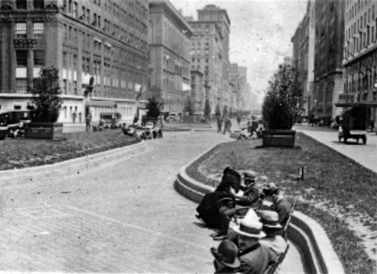
Similarly, Park Avenue was much closer to its namesake, and featured benches, shrubbery, and a path for pedestrians lining the affluent thoroughfare. In 1927, city leaders sacrificed the “park space” to accommodate cars — cutting the width of the mall in half and closing off access to pedestrians.
Park Avenue lends itself to a much larger transformation. The neighborhoods it passes through all have car ownership rates below 40 percent. Officials could remove multiple travel lanes in each direction. They could also close off the Park Avenue Viaduct to cars and redirect vehicular traffic to Madison and Lexington Avenues. This would open up the space to pedestrians and cyclists, allowing greener space that’s more welcoming for tourists and locals alike.
(Those who flock to see Manhattanhenge along the viaduct would appreciate this.)
The time to fix Park Avenue is now. Major construction is set to begin on the track beds below Park Avenue, and the medians are supposed to be ripped up and reconstructed. The opening of Grand Central Madison and the arrival of several large office towers nearby will usher in a noticeable increase in foot traffic in and around Park Avenue.
… and across the five boroughs
Broadway and Park Avenue are not the only Manhattan streets that would benefit from these overhauls. Adam Clayton Powell and Malcolm X boulevards both have medians and would benefit from transformations, and there have already been calls for this kind of overhaul. Bowery is another Lower East Side thoroughfare with heavy traffic that is greatly in need of a similar road diet.
Medians ripe for redesign exist in every borough. In Queens, Northern and Woodhaven boulevards each have similar setups that make them suitable for a transformation. Applying this practice to Atlantic Avenue in Brooklyn would also be a welcome change. And in the Bronx, University Avenue has a similar style mall between Featherbed Lane and West Tremont Avenue. There’s no reason why we couldn’t extend it further north.
These are some of the city’s widest, busiest, and most dangerous streets. Transformations in the mold of Allen Street provide safe, expansive, and protected spaces for biking and walking at a time when pedestrian and cyclist fatalities remain at unacceptably high levels.
Better infrastructure for cyclists and pedestrians gets people out of their cars, and reducing vehicular dominance is even good news for drivers. Now is the perfect time for Mayor Adams and Gov. Hochul to commit to transforming our malls.
Austin Celestin is a junior at New York University studying Urban Design and Journalism