FiDi Shared Streets Advocates Press DOT to Show ‘Urgency’ on Neighborhood Makeover
Advocates for a much more pedestrian-friendly Lower Manhattan are feeling frustrated at what they’re calling foot-dragging from the city, after the Department of Transportation gave an extremely brief update on its efforts to implement a series of shared streets in the area.
Speaking to Manhattan Community Board 1 in early June, DOT Project Manager Jenny Leung told the board that the city has barely made it out of the initial study period of a proposal known as Make Way for Lower Manhattan, a push to turn the streets of the Financial District from car-first chaos corridors to shared streets that put pedestrians and cyclists before motor vehicles on the neighborhood’s famously narrow streets.
“We have recently resumed the study,” she said. “We are currently working on updating some of the existing conditions as well as the planning efforts we’ve been working on. I know the other thing that we will we will do this year is to actually have a stakeholder engagement session.”
CB1 member Patrick Kennell pointed out that former DOT Commissioner Polly Trottenberg held a previous stakeholder meeting in February 2020. Leung said she could not provide additional information.
Members of the Financial District Neighborhood Association, the group that’s embraced the plan for shared streets in the area, said they looked forward to the latest stakeholder meeting, but were otherwise disappointed with the extremely thin update.
“I just wish there was more of a sense of urgency,” said FDNA Board Member Catherine Hughes. “There continue to be many vacant commercial retail spaces at street level and everything must be done to support those that made it through the past several difficult years — and those that have recently invested — and make it safe for those that live, work or visit FiDi. Other countries are able to successfully create shared streets in their historic centers, and New York City should be able to, as well as it envisions its precious public realm. It’s time for a pilot project now.”

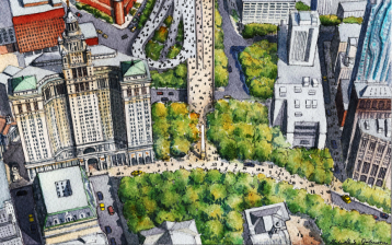
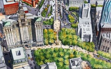
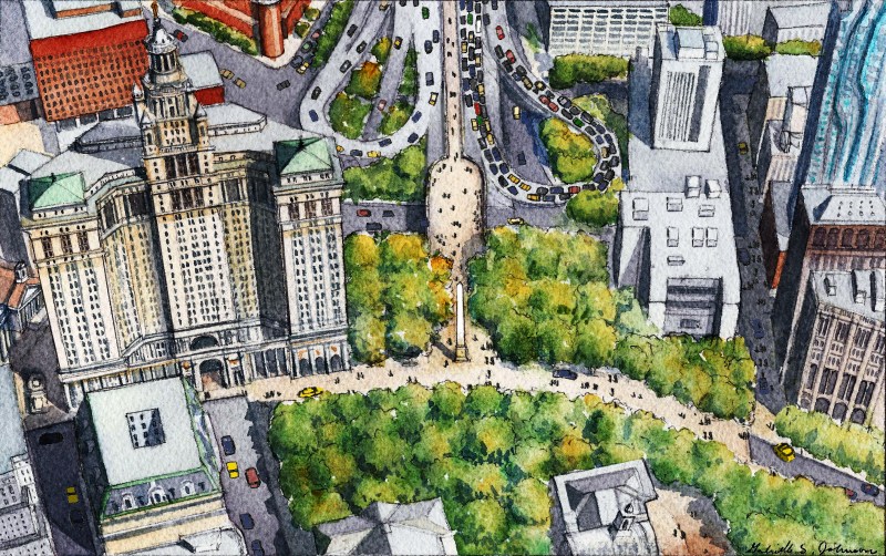
Per the Make Way for Lower Manhattan plan, the majority of the north-south and east-west corridors in the Financial District east of Broadway would be turned into shared streets with no parking and speed limits of 5 miles per hour (dark purple streets in the graphic). The remaining streets in the neighborhood would also be shared streets with the low speed limit, but would allow on-street parking (light purple in the graphic). In a future iteration of the plan, when the war on cars has been successfully been won, a pedestrian plaza would replace the Manhattan entrance of the Brooklyn Bridge.
Before the pandemic, then-Council Member Margaret Chin set aside $500,000 to pay for a study of the idea, a contract which was assigned to Sam Schwartz Engineering. The study is supposed to include stakeholder engagement, of course, but is also supposed to involve collecting data on things like auto and pedestrian traffic, curb use, off-street parking availability, garbage pickup patterns, construction activity and crash data.
The goal of the study was to take this data and create a pilot pedestrian priority area to show that the shared street proposal was workable in the neighborhood.
The coronavirus pandemic put the study on ice due to budget constraints, but the city finally appears to be moving forward with a version of it.
But not everyone; the business establishment is simply not convinced.
Jessica Lappin, the president of the Alliance for Downtown New York, was asked by Gotham Gazette’s Ben Max in May if she was interested in some kind of pedestrianization for the increasingly crowded streets of the neighborhood. Not really, she said.
“We don’t have the traditional street grid, it’s not as if you close 14th Street to buses only then you can just go on 13th or 12th or 10th or 11th, we don’t have typical sort of north-south, east-west alternatives,” she said. “We just don’t and so logistically for the fourth largest commercial business district in the city, but also for the residents who live here because they’re sprinkled all throughout the district … and they want to be able to access their buildings and they want to be able to get their deliveries as well. … It’s something we’re open to [but] it’s just a little bit more complicated if you literally look at the map of the neighborhood.”
SIDEBAR: CITY IGNORES CAR-FREE WEEKEND PLAN
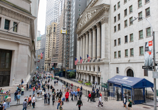
Max’s question was right on target, as FiDi has also become increasingly residential even since the 2019 plan suggested the street rejiggering. Between 2010 and 2020, the population of Lower Manhattan (which includes the Financial District and Battery Park City) grew 34 percent, to roughly 60,800 people which puts even more pressure to fit people on the neighborhood’s narrow sidewalks.
Hughes’s demand to move faster makes sense in the historical context of the shared streets proposal, which is almost 10 years old at this point. The idea was first boosted by CB1 in 2015 with a resolution that supported the shared streets concept as something that could help bring order and safety to the narrow streets of the Financial District. The FDNA’s own history on the idea also shows that the DOT did shared street pilots in the area in 2016, before the group rolled out its own ambitious, but doable, plan in 2019 to make the neighborhood street grid into a combination of slow streets with parking on some roads and with no parking on others.
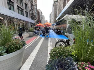
There’s a new imperative behind the plan, as the city has had much more experience with car-free and car-lite streets since the Make Way for Lower Manhattan plan was turned into pretty renderings in 2019. Residents across the city have embraced the idea of leveling the playing field when it comes to designing streets around the needs of pedestrians and cyclists just like cities have done in places like Amsterdam, Copenhagen and Bonn, comparisons that the FDNA said the city government should aspire to when rethinking the Financial District.