A Closer Look at How the L Train Shutdown Will Disrupt Transit Trips

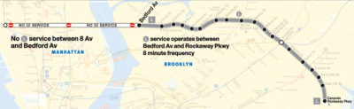
The 18-month shutdown of the L train between North Brooklyn and Eighth Avenue may be three years away, but officials still have to move quickly to help hundreds of thousands of L passengers get where they need to go. So far, city officials and the MTA have yet to provide much in the way of specifics.
To get a better sense of how transit service should adapt for the L shutdown, Annie Weinstock and Walter Hook of BRT Planning International analyzed how the loss of the L train west of Bedford Avenue would affect trip times if no measures are taken. Trips between Brooklyn and Manhattan that are currently a one-seat ride will become far more convoluted and inconvenient, as you can see in the top matrix.
Translated into time lost, the effect is most severe for L train riders who cannot conveniently connect to other subway lines at Myrtle/Wyckoff or Broadway Junction. You can see in the matrix below (which includes travel times between a sample of L train stations and other stations) that people by the Brooklyn stops west of Myrtle/Wyckoff are most affected.

In line with L train contingency plans released by other groups, they argue that the MTA should increase frequency on the J/M and G lines and allow free transfers between the G and the J/M at Lorimer, the Manhattan-bound F at Bergen Street, and Atlantic Terminal. They also recommend maintaining service frequency on the L east of Bedford Avenue.
Ferries, they note, will have limited value, since the services “help only the people near the Williamsburg and Greenpoint ferry terminals traveling to East 34th Street (and potentially E. 20th St).”
When Mayor de Blasio was asked in July about dealing with the L train shutdown, however, he emphasized ferry service as the city’s main contribution, largely deflecting responsibility for better bus service to the MTA, which can run more buses but doesn’t control the streets.
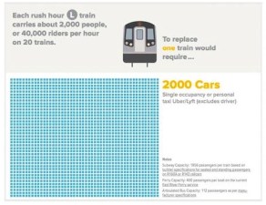
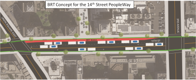
Hook and Weinstock say the city will have to claim street space for bus rapid transit routes to make up for the loss of the L. Merely adding shuttle service in mixed traffic will not be enough. “Shuttle buses that take people to subway stations would back up on already congested streets and would represent another leg in an already multi-legged trip,” they write. “Most people would not take them.”
In January, Hook and Weinstock proposed BRT routes for North Brooklyn and Delancey Street to serve displaced L passengers and meet long-term demand for transit across the East River. Based on their new analysis, they’ll be updating those plans soon.