What Can Taxi Data Tell Us About NYC Streets?
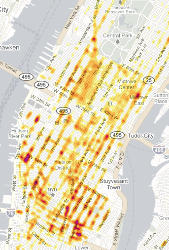 The average density of taxi pick-ups at 1 a.m. on Saturdays in 2009. The most rides originated from the Meatpacking District and the Lower East Side. Image: NYT.
When New York City installed GPS units in its taxi fleet in 2007, it began an ambitious initiative to gather information about how traffic functions. Over the last couple of weeks, the reams of taxi GPS data collected by NYCDOT received some major play from the Times, which ran stories on the intersections with the most cab hails, the days with the worst traffic, and cabbies overcharging their fares. The data is so rich, you could probably mine it for a few dozen more stories.
So we wondered, how can this trove of information be used to help pedestrians, cyclists, and transit riders?
We know that the city has already used this resource to measure the effects of street transformations. Mayor Bloomberg and Commissioner Sadik-Khan cited average vehicle speeds calculated from the GPS data when they announced the new pedestrian plazas Broadway would be permanent.
What else can this information do? We asked some of our local transportation experts and advocates about their ideas. Here’s what they told us.
"Gridlock" Sam Schwartz, former deputy DOT commish
"One possible use of the taxi data is to identify clusters of origins and destinations where it can be demonstrated that walking travel times are competitive or can be made competitive to taxi travel times. Then the city can try to make those walking trips more inviting with street designs, lighting, policing, changing signal timing to speed the walking trip, etc. Next, the city should publicize the competitiveness of walking for these trips."
Jessie Singer, Transportation Alternatives Traffic Safety Campaign Manager
The data could be used to find out how street infrastructure affects vehicle speeds. For instance, measuring "average travel speed on streets with bike lanes versus streets without."
Charles Komanoff, transportation analyst
"For some future refinements, it would be really
helpful from a social
standpoint to be able to measure instantaneous taxi speeds, not just
averages, to be able to see in which parts of the city and at which
times of day, taxis are exceeding the 30 mph speed limits and therefore
endangering other people on the road."
Frank Hebbert, Regional Plan Association Associate Planner
"Above all else, make it publicly available. The best result for the city would be to release anonymized data — that will spur all sorts of analysis and re-use with tangible economic benefit, beyond anything DOT alone can afford."
Rob Freudenberg, RPA Senior Planner for Long Island
"How about comparing taxi routes to existing subway routes? Do most taxi trips line up with existing lines or are they filling in gaps? Are they faster, slower, etc.?"
Streetsman, Streetsblog commenter, on the heat map of taxi pick-ups
"That NYTimes Taxi GPS graphic reads as a map of times and places where public transportation, particularly surface transportation, is sorely lacking. If there were frequent, highly visible buses running directly between nightlife destinations and transit hubs we wouldn’t need so many taxis clogging the streets."
Larry Littlefield, occasional Streetsblog commenter, also on the heat map
"These areas are far enough from the subway that it is not worth the hassle, but the walk to the CBD is too long. The bus is too slow, so cabs are shared for those who can afford it. But bicycles are ideal at that distance."
We have a request in with NYCDOT to see how else they plan to use this unparalleled window onto traffic behavior. If you have more ideas, tell us about them in the comments.
