Downtown Brooklyn Already Bracing for BQE Reconstruction
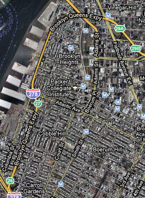
Sometime around 2019, the state DOT will begin reconstructing the segment of the Brooklyn Queens Expressway that runs through downtown Brooklyn. There are years and years of review before a shovel goes in the ground, but when construction starts, local streets already jammed with trucks and car commuters heading for free East River bridges will see even more spillover traffic. And the project itself, which will run from Hamilton Avenue to Sands Street, will have important consequences for bus transit, access to the waterfront and Brooklyn Bridge Park, and the quality of life in nearby neighborhoods.
At a meeting last night of the "stakeholder advisory council" for the project, the DOT and its consultants met with representatives of local civic groups and elected officials to discuss preliminaries. To give you a sense of just how early on the process is, the purpose of the meeting was to refine criteria the DOT will use to evaluate its options, and it won’t even be the last meeting about criteria.
What was interesting to see was how transportation engineers approach the problem of reconstructing a highway jammed through some of the most densely settled urban neighborhoods in the nation — a reminder of automobile infrastructure’s voracious appetite for space.
In engineer-speak, the BQE is "non-standard." As James Brown, a consultant with the firm HDR, put it, the engineers are "interested in standard features. Ten feet is not the standard width of a lane; interstates have 12-foot lanes." From the engineers’ perspective, the ramps and acceleration lanes are too short, he said, and the shoulders too narrow. So, in addition to keeping the BQE from disintegrating, the project may widen and lengthen certain parts of the roadway. Much of the discussion last night centered around how to prioritize neighborhood quality of life and the public realm while addressing the genuinely hazardous roadway conditions in need of attention.
The project also presents some real opportunities. If, God forbid, we still have free East River bridges and one-way tolling on the Verrazano in 2019 — both significant contributors to the traffic crunch in downtown Brooklyn — this mammoth construction project and its spillover traffic could add some urgency to any push for pricing those crossings rationally. Kyle Wiswall of the Tri-State Transportation Campaign, who attended last night’s meeting, noted that the reconstructed highway segment could also incorporate a dedicated bus lane or HOV lane, extending some of the traffic management strategies in place on the Staten Island Expressway and the Gowanus.
At this stage of the process, DOT hasn’t come out with any designs to comment on, and it’s too early to say how the project will impinge on the neighborhoods around it. Wiswall said it would be difficult to imagine the state DOT opting to pursue a de facto expansion project — as the agency almost did with the Major Deegan last fall — in such a tight space. But he added that advocates should keep an eye out for mission creep. "We have to make sure the scope doesn’t ramp up so the shoulders become a travel lane and then you get a bigger, noisier highway and you lose those safety gains," he said. "It’s our job to make sure they stay focused on that and it doesn’t turn into a capacity project."
