Livable Streets Community News: Mapping Hotspots, Getting Results

PSCC1.jpg
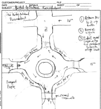
A workshop participant diagrammed these traffic-calming proposals for Bartel Pritchard Square.

If you want to use the Livable Streets Community site to organize in your neighborhood, this week we’ve got a great example of what you can do with your group.

On February 7, Brooklyn’s Park Slope Civic Council put on a workshop to introduce people to the livable streets "toolkit" and gather ideas for improving the public realm in the neighborhood. As their final report [PDF] explains, "The workshop was aimed explicitly at ordinary citizens, not transportation or planning professionals or members of advocacy groups."

The workshop brought together 50 people from the neighborhood, who mapped out an inventory of 120 "hotspots" of particular concern. Speeding quickly came to the forefront as a detriment to pedestrian safety and quality of life, with Eighth Avenue, Prospect Park West, and Union Street targeted as problem areas.

After completing the report, the Civic Council submitted it to DOT and other city agencies. One immediate benefit has been the improved line of communication between the Civic Council’s Livable Streets Committee and the 78th Precinct. Lauri Schindler — who organized the workshop — tells us that police often receive mixed messages from communities about how to enforce speeding and other traffic laws. The feedback captured in the report, she explains, opened some eyes: "They were glad to see enforcement issues as considered key in livable streets."

The Civic Council is looking forward to sharing their techniques with other neighborhoods. "Eighth Avenue is a unique location but speeding is
not unique," says Schindler. "We want to work with other communities on these shared issues."

If you’re interested in mapping the livability of your streets, check out the final report, available on StreetsWiki as well as the Civic Council’s site.

ALSO ON STREETSBLOG

This Week: Traffic Calming for Co-Op City and Park Slope

|
This week’s calendar — particularly Tuesday evening — is packed with livable streets events, including community board meetings for traffic calming in Co-Op City and Park Slope. Here are the details: Monday: Join Park Slope Neighbors for a happy hour to benefit Riders Alliance and its campaign for better bus and subway service across the […]

This Week: Bronx Candidate Forum, Safer Amsterdam Avenue

|
The 15th City Council district has seen some notable livable streets changes in the past 6 years, including the addition of two Select Bus Service routes. Will the momentum continue? The candidates to replace term-limited Council Member Joel Rivera square off tonight at a forum about neighborhood health and environmental sustainability. Also this week: Speak […]

This Week: Burst of Community Board Action Before Summer

|
The second and final Manhattan Vision Zero workshop is scheduled for this evening, as are opportunities to weigh in on bike infrastructure in Brooklyn and buses in Queens. The week continues with community board meetings on bike lanes, Slow Zones, improving dangerous intersections, and securing complete streets on two of Manhattan’s busiest avenues. For the […]

Community Benefits Agreements: What Do They Mean for Livable Streets?

|
A rendering of the CBA-mandated walkable development slated for the Longfellow neighborhood of Minneapolis. Image: UrbanWorks Architecture. Last week, Comptroller John Liu announced plans to convene a task force to study and issue recommendations about community benefits agreements in New York. While details on the task force are still forthcoming, the renewed public attention on […]

The Other Livable Streets Showdown in Park Slope Tomorrow

|
By now you’ve probably heard about the big rally to defend the Prospect Park West bike lane tomorrow morning. Everyone who can attend should make every effort to get to Grand Army Plaza at 8:00 a.m. and show how deep the support for the PPW re-design runs. There’s another event happening tomorrow that has big […]