City Safety Plan for Queens-Bound Cyclists: A Wrong-Way Detour
City & State NY is hosting a full day New York in Transit summit on Jan. 30 at the Museum of Jewish Heritage. This summit will bring together experts to assess the current state of New York’s transportation systems, break down recent legislative actions, and look towards the future of all things coming and going in New York. Join Keynote Speaker Polly Trottenberg, commissioner of the NYC Department of Transportation, along with agency leaders, elected officials, and advocates. Use the code STREETSBLOG for a 25-percent discount when you RSVP here!
A city proposal to improve a crucial, yet horrifying, route for cyclists between Greenpoint and Long Island City would add significant safety infrastructure, but also force cyclists two blocks out of their way — all because the city refuses to inconvenience car owners and their insatiable need to store their vehicles.

The Department of Transportation plan for the dangerous Kent Avenue-Franklin Street corridor [PDF] would no longer force riders to share the narrow roadway of Franklin Street with buses and other vehicles. But that improvement comes with a price: cyclists would only get full protection if they detour off Franklin Street to West Street, one block to the west (see map, right).
DOT officials presented the plan on Wednesday night to members of Community Board 1, who received it with little rancor or enthusiasm. Let’s break it all down:
The plan
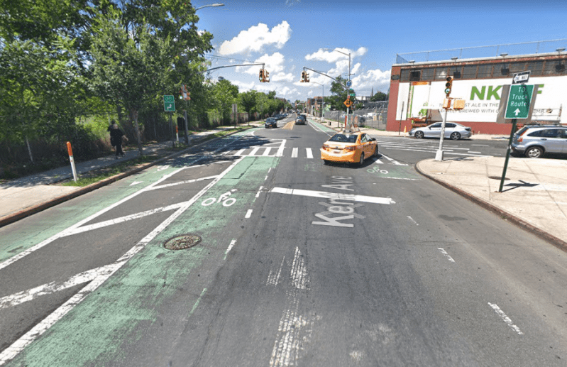
Currently, Queens-bound cyclists heading north in the protected bike lane on Kent Avenue reach a dangerous intersection at North 14th Street, where the protected bike lane on the west side of Kent not only loses its protection, but also flips, across traffic, to the east side of the street.
Within a couple of blocks, the northbound roadway narrows and the bike lane becomes a shared lane, putting cyclists in the path of buses, trucks and cars. It’s a very dangerous route — with 38 reported crashes in two years, injuring six cyclists, one pedestrian and seven motorists along just six blocks of Franklin Street.
Most cyclists have gritted their teeth, gutted it out and prayed to whatever god they have as they make their way on Franklin to one of the two crossing points into the Borough of Roses: The Pulaski Bridge (remaining on Franklin Street north to Eagle Street) or the Greenpoint Avenue Bridge (remaining on Franking Street, but turning right onto Greenpoint Avenue).
Neither is a great option, which explains why the DOT sought a fix.
The positives
The DOT plan would eliminate the most fearsome part of this stretch of the Brooklyn-Queens Greenway: the spot where Kent Avenue becomes Franklin Street — and cyclists flip from the safety of the protected bike lane to the danger on the east side of the street.
Instead, the two-way protected bike lane on Kent Avenue will continue on the west side of Kent all the way to Quay Street.
Cyclists will likely cheer that change.
“This eliminates one of the scarier points,” said Brooklyn cyclist and activist Philip Leff. “Having to merge into fast-moving traffic on a truck route is pretty daunting even for experienced cyclists. This drastically reduces the threats of dooring in the current southbound lane, and the frequent blockages of the northbound lane.”
The plan also gives cyclists a protected bike lane between N. 14th and Quay streets. And that protection would continue on Quay to the protected bike lane on West Street.
The negatives
The plan does not challenge the city’s prevailing narrative: roadways are for the movement and storage of cars — and cyclists can only be accommodated if there’s room.

But here’s the problem: From now until tectonic shifts alter the continental plates, the most direct route for Queens-bound cyclists remains Franklin Street. But the DOT has proposed no changes at all north of Quay Street, so Franklin will remain a shared space. That will maintain the current war: cyclists are pit against car drivers, B32 bus drivers and people who store their cars along both curbs of the commercial strip between Quay and Eagle streets.
The city could have continued the protected lane along Franklin Street, but that would have required a substantial redesign and the removal of lots of car storage.
Leff was disappointed.
“I am concerned that no safety improvements are planned for a busy street [Franklin] with a demonstrated record of injuries and fatalities,” he said. “There are still plenty of reasons cyclists will want to access Franklin Street: businesses, residences, and the most direct route to the Pulaski Bridge. Why the mayor and his DOT continue to prioritize parking and speeding trucks through residential neighborhoods is a question only they can answer.”
We asked DOT to respond, and got this statement from spokesman Brian Zumhagen:
DOT investigated several design options including removing parking. Our proposal is to relocate parking from the west curb to the east curb along this portion of Franklin Street in order to accommodate deliveries and retain curb access for neighborhood businesses. We are in the final stages of transferring ownership. When the transfer is complete, DOT will add green paint and vertical delineation to deter/limit vehicle incursion on the bike facility. The vertical elements can be added over the winter, and paint will be implemented in late spring after the weather warms up. Cyclists wishing to take a more direct route may remain on Franklin Street.
Before the plan can truly be considered a success, the city will have to fix the existing bike lane on West Street — a known catastrophe because cars and trucks are almost constantly parked in it (prompting the Streetsblog headline last year, “Live from West Street: It’s NOT a Protected Bike Lane If Cars Can Park On It”).
As Rene Magritte would have said, “Ceci n’est pas un protected bike lane,” we reported at the time.
The city *and all of us* spent over $28 million for a fancy truck parking lane on West Street in Greenpoint, when we thought we were getting a new ? path
Local police say the trucks they ticket just come back again the next day https://t.co/lsz3JUHHT1
— Bike New York (@bikenewyork) September 19, 2019
“The set-up now [on West Street] is if the non-path lane curb is parked up, cars stop in the single travel lane and then cars and trucks going around it drive in the bike path,” said Jon Orcutt of Bike New York, who lives in the neighborhood and has long complained about West Street.
Summary
There is no question that riders using the proposed bike route will be safer than they currently are. And newbie and less-comfortable cyclists will feel safe, which will only encourage more cycling. Those are good things.
And the new protected route may connect, eventually, to other protected routes that could be, as Leff put it, “the backbone of a truly protected citywide bike network.”
But the city had a chance to take away some public space currently set aside for the storage of parked vehicles — in other words, space that is currently unused for the efficient movement of people and goods — on Franklin Street, and opted against it.
Instead, cyclists have to make a detour, while drivers maintain hegemony over one of the busiest bike routes in Brooklyn.
That’s a missed opportunity — one that might be repeated when, say, the city is called upon to protect cyclists on Greenpoint Avenue, another chokepoint. There is no evidence that DOT will push back against drivers when that time comes.
For now, Orcutt said he was satisfied with half a loaf.
“You’ll still be free to ride up Franklin Street if you want to, but for someone who is afraid or uncomfortable in that kind of environment [will] have a much cleaner, safer route for only a short detour,” he said.
