Behold the First Bike-Share Expansion Maps of 2017

What's in store for parts of Astoria, Crown Heights, and Prospect Lefferts Gardens.
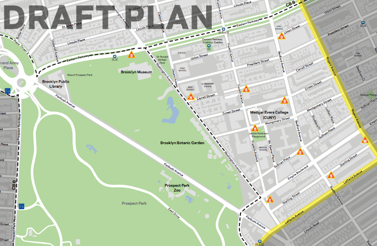
All the proposed bike-share stations in Brooklyn Community Board 9 would take up sidewalk space, not parking spots. Image: NYC DOT

DOT has released preliminary station locations for two areas in this year’s Citi Bike expansion. The maps will be finalized by June, agency reps told the Brooklyn Community Board 9 transportation committee last night. (The process of locating the new stations began with public workshops in the fall.)

The expansion into Prospect Heights, Crown Heights, and Prospect Lefferts Gardens will extend to Rogers Avenue. This won’t reach as far east as the system does in Bedford-Stuyvesant, where stations are located up to Malcolm X Boulevard.

DOT presented 10 station locations in its draft map for CB 9 [PDF], which covers a relatively small area between Eastern Parkway and Lefferts Avenue. The station density works out to a healthy 38 per square mile if you don’t count the Brooklyn Botanic Garden and Prospect Park, but all 10 stations will be located on sidewalks.

DOT also presented its draft Astoria map to Queens CB 1 on Tuesday [PDF]. That zone cover a larger area (three square miles) and will be getting 59 stations. That comes out to about 19 stations per mile, significantly less than the 28 recommended by the National Association of City Transportation Officials.

Queens Community Board 1. Image: <a href="http://a841-tfpweb.nyc.gov/bikeshare/files/2017/04/Brooklyn_CB9_DraftPlanMap_20170405.pdf">DOT</a>
Queens Community Board 1. Image: DOT

In Manhattan, Citi Bike will be expanding from 110th Street to 130th Street. Those station maps were released last year.

Parts of Queens CB 2 and Brooklyn CB 8 are also included in the expansion. DOT will present draft station maps to Brooklyn CB 8 on April 25, according to DNAinfo, and to Queens CB 2 next month. The new stations will be installed by the end of the summer.

ALSO ON STREETSBLOG

Eyes on the Street: DOT Wayfinding Signage in Prospect-Lefferts Gardens

|
Noah Budnick at TA tweeted this shot yesterday of a new pedestrian wayfinding sign at Flatbush Avenue and Empire Boulevard, between Prospect Park and the Brooklyn Botanic Garden. Unlike traditional maps, where north is up, WalkNYC maps are oriented to the direction the viewer is facing. Initial rollout areas include Chinatown, the Garment District, Herald […]

Citi Bike Could Expand to 86th Street This Summer

|
It looks like some parts of Manhattan north of 59th Street could be getting Citi Bike sooner than previously expected. At a town hall hosted by Council Member Helen Rosenthal last week, DOT Manhattan Borough Commissioner Margaret Forgione said Citi Bike would expand to 86th Street by August or September, and to 110th Street “probably in March,” […]

The Campaign for a Better Street Safety Conversation in PLG/Crown Heights

|
Last night, Transportation Alternatives’ Brooklyn Activist Committee and the Prospect Lefferts Gardens Neighborhood Association hosted a #SlowDownPLG workshop for neighborhood residents to share ideas about walking and biking safety in the neighborhood. Around 35 people attended and worked in small groups to address concerns on five streets: Ocean Avenue, Flatbush Avenue, Rogers Avenue, Nostrand Avenue, and Empire […]

This Week: Hudson Greenway Detour, Bike-Share in Brooklyn

|
This summer the Parks Department presented a plan to route cyclists away from the waterfront greenway and onto a hilly, poorly-lit path between 72nd Street and 83rd Street. The greenway can get crowded along the water on summer days, but most of the time the current path doesn’t pose a problem. Nevertheless, as presented, the Parks Department’s proposal […]

Empire Boulevard Reconstruction Will Create Two Plazas

|
Dangerous intersections at each end of Empire Boulevard, which stretches east-west across the southern edge of Crown Heights, are set for some major new pedestrian space. A street reconstruction project will reconfigure the area where Empire Boulevard, East New York Avenue, Remsen Avenue, and Utica Avenue converge. There, DOT will reroute traffic, creating a new pedestrian plaza. Similar changes […]