Sandy Aftermath: Where Would You Reserve More Space for Buses and Bikes?

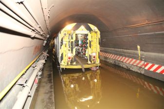
As the flood waters recede from New York City, it looks like the effects of Hurricane Sandy are going to linger in the city’s subway tunnels. MTA Chair Joe Lhota has called the storm the most devastating disaster to strike the subway system in its 108-year history.
All seven subway tunnels under the East River have flooded. So have several rail yards, though the MTA removed rolling stock to higher ground, preventing damage to subway cars. The exact extent of the damage to tracks, signals, and switches was unknown as of this morning, with Lhota telling WNYC that the MTA would have a firmer assessment later today.
At some platforms, the flooding is all the way up to the ceiling, Lhota said at an 11:30 press conference. The agency is currently in the process of pumping out the tunnels. While the subway system is out of service and gradually comes back online, Lhota said, “We’re going to use the bus system to complement and supplement” the subways.
Right now there is no definite timetable for restoring the subways. Speaking to the press this morning, Mayor Bloomberg said that he hoped some buses would be running this afternoon, with most bus service potentially resuming tomorrow. “Getting transit up and running is going to take more time and a lot of patience,” he said. “The damages they face really are enormous.”
At the 11:30 presser, Governor Cuomo said that the process of getting trains up and running will be “more about restoration of parts of the subway system first.” After the whole transit system is back online, he said, there will need to be a “long-term reconstruction effort,” referring to the region-wide process of recovery from the storm and flood damage.
For the immediate future, it seems, NYC will be without the main arteries of its transportation system, which means the city is going to have to wring more efficiency out of its surface streets.
In the past, large-scale transit disruptions have prompted officials to take innovative steps to keep New Yorkers moving. The 12-day transit strike in 1980 famously led to a surge in bike commuting, experiments in new bike infrastructure, and an ill-fated Koch administration proposal to compel single-occupancy vehicles to take the tolled crossings across the East River instead of the traffic-clogged free bridges.
After the September 11th terrorist attacks, the city for a time banned single-occupancy vehicles from entering Manhattan below 62nd Street, and bus-only lanes were implemented or expanded on Church Street in Lower Manhattan, in the Lincoln Tunnel, and on the Gowanus Expressway [PDF].
During the 2005 transit strike, the city’s plan called for tight HOV restrictions — allowing only cars with four or more passengers — on many highways and river crossings. The city also identified major north-south and east-west streets in Manhattan as “reserved streets” where only buses, emergency vehicles, commuter vans, and motorcycles were allowed.
As New Yorkers get back to work and resume our daily routines in the wake of the storm, we’re going to need innovative measures to keep us moving. Without the subways, most New Yorkers don’t have the option of driving to work, and if people who do own cars start driving solo, the streets will seize up. Dedicated space for buses, bikes, and high-occupancy vehicles will be essential.
In a press release, Transportation Alternatives recommended the following measures “to assist stranded New Yorkers and prevent gridlock”:
– Emergency Bus Lanes to allow swift transit throughout the City until subway service is restored.
– Emergency Street Reservations exclusively for the safe use of walkers, bikers and emergency vehicles.
– Off-Peak Bridge Biking and Walking Lanes to ensure sufficient safe space for people on foot and bicycle and prevent overcrowding on the bridges.
– Emergency Biking Lanes on well-used routes to enable safe mobility, including coned-off Midtown bike lanes.
– Bike Parking Stations and Temporary Bike Storage in major employment centers in Lower Manhattan including Foley Square, Union Square, Herald Square, Times Square, Washington Square Park and Bryant Park.
– High Occupancy Vehicle Requirements on crossings into the most congested areas of the city.
– Carpool Staging Areas offering parking and passenger pick-up locations in support of drivers sharing rides to meet the HOV requirements.
So, while we’re waiting for the official post-Sandy transport plan, let’s open this up. Where would you reserve more room for spatially-efficient transportation modes, Streetsblog readers?

