Upper East Side Workshop Kicks Off New Street Safety Campaign
"You can’t control what you can’t measure," the saying goes. So to get a better grip on street safety on Manhattan’s East Side, Transportation Alternatives started by collecting better data about local traffic collisions and injuries. Last night, a group of Upper East Siders used that information to begin imagining what a safer neighborhood might look like.
The safety data and the workshop are part of a new campaign
organized by TA called the East Side Streets Coalition, which aims to dramatically improve safety from East
Harlem to Chinatown. The goal is to reduce traffic collisions that injure and kill pedestrians and cyclists by 50 percent over the next ten years.
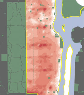 Upper East Side workshop participants discussed street safety using a new map of the most frequent sites of traffic collisions that injure pedestrians and cyclists. Click here for the full version of the map, showing the whole East Side. Image: Transportation Alternatives.
 "Other areas of Manhattan have seen significant street improvements in the last few years," said TA campaign coordinator Julia Day. "A lot of the East Side’s major corridors haven’t benefited from these improvements." As a result, she said, the East Side has some of the most dangerous streets in the city. The densely-populated Community Board 8 district on the Upper East Side, for example, suffers from the third most crashes of any community district in the city.
The campaign started by mapping out precisely where pedestrians and cyclists are most at risk of getting hurt by cars. Using advanced mapping techniques and new data from the state Department of Transportation, TA has identified and visualized the intersections where the most crashes occur along the entire East Side. These intersections will be the principal targets of the campaign. (The campaign will explicitly refrain from focusing on First and Second Avenues, which are already slated to receive major pedestrian and cyclist safety features.)
The coalition is beginning outreach to develop a vision for a redesigned East Side. The first workshop, for Upper East Side residents, was held last night, with about thirty participants meeting in the cafeteria of the Wagner Middle School to share their concerns about local streets and develop solutions.
Using tools like the city’s Street Design Manual and detailed maps of some of the most dangerous intersections in the district, they plotted out their safety ideas. Some of the most popular fixes, like leading pedestrian intervals or sidewalk extensions, would make sense throughout the city. Others were specific to the neighborhood or even the intersection.
One especially interesting proposal was to give 86th Street, where two deep red ovals are visible on the safety map, the same treatment that DOT is proposing for 34th Street: a physically separated bus lane and a full block closed to cars. As Upper East Side resident Steve Vaccaro noted while presenting this idea, 86th Street is choked with cars even though it doesn’t actually connect anything; the street doesn’t directly connect to either the FDR Drive or a Central Park transverse.
The solutions didn’t fall on deaf ears. City Council Member Dan Garodnick gave opening remarks, telling the group that he "will be very eager to look at the plans and then advocate for them." Representatives from Assembly Member Jonathan Bing and Council Member Jessica Lappin’s office also participated in the group exercises and presented ideas.
The workshop was a success in another respect as well. Two local organizations, the E. 86th Street Association and Upper Green Side, became the first members of the East Side Streets Coalition, in addition to a local committee composed of TA members. According to Day, more organizations have already committed to joining the coalition but haven’t officially signed on yet. Five more visioning workshops are scheduled for the rest of the East Side between now and mid-May.