TA Rolls Out CrashStat Improvements
cs1.jpg
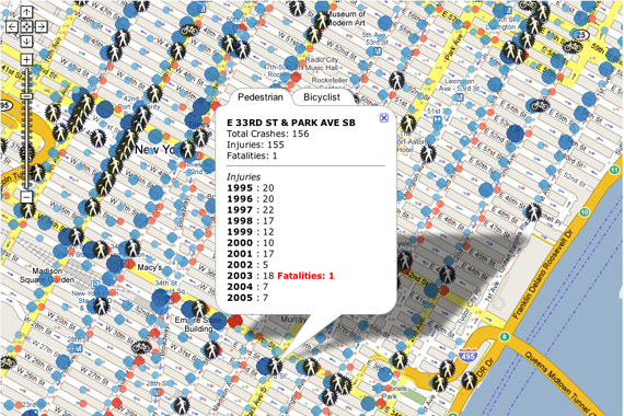
E. 33rd St. and Park Ave. was the city’s most dangerous intersection between 1995 and 2005.

Transportation Alternatives’ CrashStat 2.0 is now out of beta, with improvements in performance and functionality.

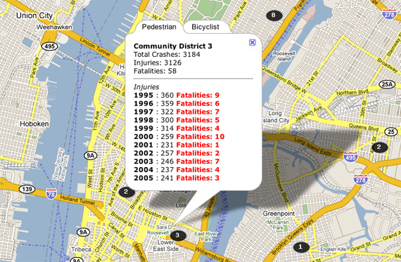
The most obvious change is that the data loads a lot faster, and the icons are cleaner. There are more data points, too: the map now features stats by borough as well as community district. And there are icons indicating community facilities like schools and hospitals.

Originally launched in 2004, CrashStat allows users to access official data on city pedestrian- and cyclist-involved crashes from 1995 to 2005.
cs2.jpg
Stats are now viewable by community district.

ALSO ON STREETSBLOG

Crashstat 2.0 Reveals NYC’S Most Dangerous Intersections

|
Crashstat shows Fordham Rd. in the Bronx to be one of the most dangerous streets in New York City. For years, Livable Streets advocates have pushed New York City government to make citywide pedestrian and cyclist crash data more accessible to help civic groups and policy makers make more intelligent street design improvement decisions. Rather […]

CrashStat Upgrade Provides Interactive, Up-To-Date Street Safety Data

|
Transportation Alternatives launched an updated version of its CrashStat website today, providing a wealth of new data about street safety in New York City and where pedestrians and cyclists are most at risk. The upgrade adds four years of geo-coded data about traffic injuries and fatalities, a smoother interface, and a wealth of interactive features. […]

Open Thread: How Would You Use City Traffic Crash Data?

|
On Monday Transportation Alternatives released a report tallying pedestrian-involved crashes in each of the city’s community board districts, based on numbers from the state Department of Motor Vehicles, between 1995 and 2009. Not surprisingly, the data reveal that the most collisions occurred in Midtown Manhattan, where high-density auto and foot traffic led to 8,604 crashes […]

DOT to Hold Woodhaven Boulevard Forum Tonight

|
  Here’s another opportunity for livable streets advocates to make themselves heard tonight: DOT will be hosting a public input session regarding congestion on Woodhaven Boulevard in Queens, focusing on the area between Queens Boulevard and Liberty Avenue. Subjects to be discussed include: Traffic Volume, Roadway Alignment, Mass Transit, Physical Constraints and the Service Road. […]

Pedestrian Safety in Brooklyn Heights

|
Pedestrian injury and fatality data from the Transportation Alternatives Crash Map A note from Transportation Alternatives putting this morning’s pedestrian fatality in Brooklyn Heights in context: This morning’s pedestrian fatality on Henry Street and Montague Street in Brooklyn Heights is not an isolated event. According to Transportation Alternatives’ Crashstat data, six pedestrians have been hit […]