East 106th Street Road Diet and Bike Lanes Head to Manhattan CB 11

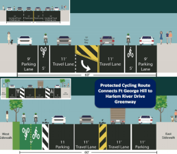
Running between Fifth Avenue and FDR Drive, 106th Street in East Harlem should provide a key bike connection between Central Park and Randall’s Island. NYC DOT is proposing a road diet and painted bike lanes [PDF] to improve safety on the street, and Community Board 11’s transportation committee could vote on the plan soon.
At 60 feet wide, 106th Street currently has two car lanes in each direction, even though one lane each way could handle the existing traffic. The connection to the Randall’s Island bike-pedestrian bridge at 103rd Street is also tricky to navigate. This is especially important since 106th Street is the most direct connection between Central Park and Randall’s Island, due to the prevalence of large super-blocks in East Harlem.
The present design contributes to the disproportionate share of traffic violence on East 106th Street. There were two pedestrian fatalities in separate crashes in 2005, and a cyclist was killed at the intersection with Park Avenue in 2000, according to CrashStat. It ranks in the top third of Manhattan’s most dangerous streets, according to NYC DOT.
DOT is proposing a classic four-to-three lane road diet, converting the existing four car lanes to two car lanes, bike lanes, and a center median with left-turn lanes. At Second and Third Avenues, median islands would make intersections safer for pedestrians by turning one 60-foot crossing to two 25-foot segments.
Between Fifth and Madison Avenues, the plan eliminates the center median and the bike lanes, which give way to sharrows in order to maintain angled parking on 106th Street for the Terence Cardinal Cooke Health Care Center.

The plan includes a painted curb extension on the northeast corner of First Avenue and E. 102nd Street, with a new bike lane on 102nd Street leading to the Randall’s Island bridge.
The agency presented the plan to CB 11’s transportation committee on April 1 and held a walk-through on Monday morning. The tour attracted about 25 people, according to CB 11 assistant District Manager Angel Mescain-Archer. He said that “there may have been concerns about loss of parking or bus stops, but DOT clarified that this plan would have no effect on either.”
The walking tour could result in one change: Where 106th Street meets the FDR Drive service road, DOT is proposing a striped two-way bike lane on the east side of the service road to connect to 105th Street, where cyclists can access the bridge to Randall’s Island. The M106 bus also follows this route. “We witnessed several buses navigating that turn and it was very clear that there simply is not enough room to safely accommodate the turning bus and the bike lanes,” Mescain-Archer said.
Mescain-Archer said a slightly modified version of the plan is likely to be presented to the board’s transportation committee again. Its next meeting is scheduled for May 6.
