DOT Narrows Dangerous Staten Island Corridor With More Parking, Unprotected Bike Lane

City officials want to curb rampant speeding and traffic violence on one of Staten Island’s most dangerous roads with cutting-edge urban planning technology: adding more parking and painting a bike lane.
The Department of Transportation’s proposal, revealed last week, would narrow Lincoln Avenue from two chaotic lanes to one between the Grant City Staten Island Railway stop and Midland Beach [PDF] — a missed opportunity to add much-needed protected bike lane miles, bike advocates said.
The 1.16-mile stretch between Father Capodanno Boulevard and North Railroad Avenue is in a Vision Zero priority corridor, having one of the highest rates of traffic violence in the borough, according to DOT. Drivers speed through so often that local NYPD officials actually asked the agency for a redesign, Project Manager Martha Isaacs told local Community Board 2 during a virtual presentation last Tuesday.
“These treatments will reduce speeding and calm traffic, which the New York City Police Department requested that we do to address the speeding issues on Lincoln Avenue,” Isaacs said.
The roadway’s 30- to 37-foot width and sparse markings currently encourage reckless driving, Isaacs said. Nearly 80 people suffered injuries in car-related crashes there between 2016-2020, including four pedestrians who were injured seriously, NYPD records show. One single speed camera near the Grant City railway station caught more than 6,000 speeding violations between July 2021 and June 2022 — an average of 25 per day, according to DOT.
Last year there were 31 crashes along the corridor — more than two a month — injuring 16 people, 14 of them in cars and two pedestrians.
DOT’s redesign would make the northern curb between Father Capodanno Boulevard and Boundary Avenue — which today becomes a second driving lane for three hours during the evening rush — into around-the-clock car storage:

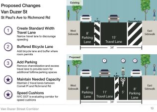
The block between Boundary Street and Hylan Boulevard would not change under DOT’s plan. West of Hylan Boulevard, where the roadway grows to 37 feet, the city plans to narrow the two current lanes to one, and add an exposed bike lane with a three-foot painted buffer:

The agency also hopes to paint curb extensions and add crosswalks outside Public School 38 at Lincoln Avenue and Pultney Street. Residents and school officials have long asked for speed bumps on Lincoln Avenue — but DOT is only allowed install those features on single-lane roadways, which officials plan to do at five spots after the conversion, Isaacs said.
Advocates acknowledged the potential safety improvements, but said the city should have been more ambitious, especially as DOT has failed to meet its annual quota of new protected bike lanes under the Streets Plan.
“They know that this is a dangerous area, and yet we’re still getting this subpar infrastructure,” said Rose Uscianowski, a Staten Island organizer with Transportation Alternatives. “We’re always years behind.”
The city has been able to install protected lanes on similarly wide roads in other boroughs for years, noted Brandon Chamberlin, who has kept detailed track of DOT’s progress for new paths.
In 2023, @NYC_DOT is proposing unprotected #bikeNYC lanes on 37’ wide outer boro streets despite saying for years that 34’ wide crosstown streets in Manhattan fit protected bike lanes. Not going to meet the #NYCStreetsPlan requirements like this. https://t.co/jOLXE6yzaI pic.twitter.com/XJB5CQmqXj
— BrandonWC (@BrandonWC) April 12, 2023
On the tony Upper East Side for example, DOT designs from two years ago were easily able to fit a protected bike lane into roadways of the same widths.

On Lincoln Avenue, DOT would have to probably get rid of parking on one side of the narrower section to fit a protected bike path. But on the wider stretch west of Hylan Boulevard, the agency could simply flip the parking to the other side of the planned cycling path.
The lesser bike lanes do cause serious injuries and deaths to decline, noted DOT spokeswoman Mona Bruno — about 15 percent among all road users and 16 percent for pedestrians. But a protected bike lane decreases those rates even further — by 18 percent for all road users and 29 percent for pedestrians.
The agency rep didn’t directly answer Streetsblog’s question why they opted against a protected bike lane on Lincoln Avenue, but listed off the project’s upgrades.
“This project is primarily focused on calming traffic through a variety of treatments that have shown to significantly improve safety, including the removal of a travel lane; shortened crossing distances; the addition of an all-way stop sign; five speed humps; two curb extensions; new crosswalks; and a conventional bike lane,” said Bruno.

