EYES ON THE STREET: New Kew Gardens Interchange Path Benefits Walkers, Bikers
A shared-use path among a spaghetti of highways could become a piece of of a cross-Queens bike network.

A new shared-use path amid a tangle of highways in central Queens is creating an important, safer connection for bikers and walkers.
The path, moreover, could become an important piece of a bike network connecting Eastern and Western Queens — a longtime goal of cyclists.

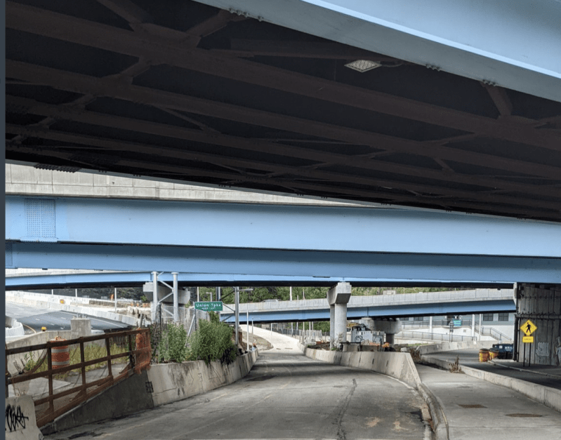
The shared-use path connects Park Drive East in Kew Gardens Hills to Queens Boulevard in Forest Hills and comes as part of the fourth and final phase of the reconstruction of the Kew Gardens Interchange, which sits at the confluence of Forest Hills, Kew Gardens, Kew Gardens Hills, and Briarwood.
The state Department of Transportation has been reconstructing the interchange — which funnels vehicles from the Van Wyck Expressway, Grand Central Parkway, and Jackie Robinson Parkway — since 2010 in an attempt to improve traffic flow. Yes, that’s the famous “bottleneck” — a long-time star of morning traffic reports — where roads bringing drivers from the Bronx, Brooklyn, Long Island, and Manhattan converge at the approach to JFK.
But if car drivers are going to have a new interchange, at least other modes finally got some infrastructure!
In Queens, alas, you are never far from a highway. Even a verdant, residential neighborhood like Kew Gardens Hills is hemmed in by two highways: the Grand Central Parkway to the south and the Van Wyck Expressway (and Flushing Meadows-Corona Park) to the west.
Like many outer borough neighborhoods, Kew Garden Hills lacks direct subway access; residents who commute by public transit usually take the Q46 bus down Union Turnpike to the E/F at Kew Gardens or the Q64 on Jewel Avenue to the E/F/M/R at Forest Hills if they need to get to Manhattan, while some take the express buses or the 7, J/Z, or LIRR at Flushing or Jamaica.
But not all trips out of the neighborhood are by public transit — which is why the new shared-use path is so important. For those living closer to Park Drive East (which parallels the Van Wyck) walking directly to the Kew Gardens Union Turnpike station at Queens Boulevard along the Kew Gardens Interchange can take less time than walking to the bus that takes them to the same place.
And many people whose full trips are not well-served by the existing public transit routes often opt to bike to their destination. So a sizable number of residents walk or ride bikes across the Kew Gardens Interchange daily.
Until recently, the trip was dangerous, involving two crossings where cars travel at highway speeds: once at the on-ramp from Union Turnpike to the Westbound Grand Central Parkway at Park Drive East, and again at the off-ramp from the Southbound Van Wyck Expressway to Union Turnpike.

The route also required both walkers and bikers to traverse a narrow, cracked sidewalk with no barrier between them and the high-speed roadway — creating conflicts. Cyclists had little choice but to use the sidewalk: Motorists drive at highway speeds on Union Turnpike, one of only two streets leading west out of Kew Gardens Hills (the other is dangerous Jewel Avenue).

The new shared-use path, happily, eliminates these issues. The path starts on a former entrance ramp to the Grand Central (the entrance has been pushed further east). It then dips under a ramp from the Van Wyck, leading users down toward a brand-new concrete path that climbs upward to meet Union Turnpike. The path then continues along Union Turnpike, with a concrete barrier separating path users from the highway traffic. The barrier eventually gives way to a chain-link fence, which disappears as the road approaches Queens Boulevard.

The shared-use path also could help build a cross-Queens bike network: To the west, it ends at Queens Boulevard, where a protected bike lane runs from Union Turnpike to Greenpoint Avenue in Sunnyside. The Queens Boulevard lane itself is not far from Forest Park, with paths that can get riders west to Glendale. Meanwhile, advocates hope to extend the Queens Boulevard bike lane’s eastern terminus to Jamaica — an important transit hub and prime shopping area. The city should invest in building out these connections.

The new path’s eastern end is not ideal: It drops users at Park Drive East and Union Turnpike, three blocks short of a painted bike lane that ends on Park Drive East. NYC DOT should build out the lane on Park Drive East to connect it to the new shared path.
Altogether, however, I’m pretty happy with the new path!
Yehuda Pollack (@Yewhomstda) lives and bikes in central Queens.


