Eyes on the Street: The Broadway Bridge Construction is a Clusterf—k
The aged span is undergoing a long-overdue rehab — but the Department of Transportation has created perilous conditions.


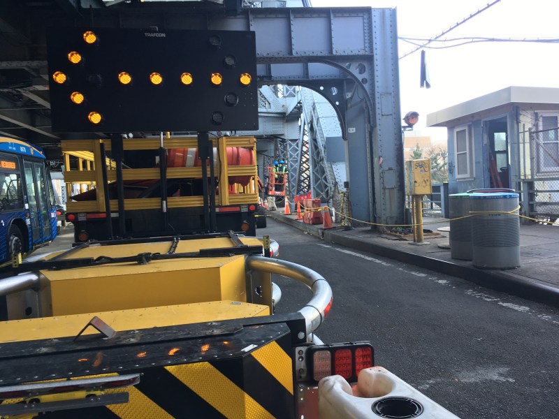
The city is is worsening unsafe conditions as it rehabs one of the major Harlem River crossings, the 558-foot-long Broadway Bridge spanning the Spuyten Duyvil Creek between Inwood and Marble Hill at West 225th Street.
The aging two-deck lift bridge, completed in 1962, needs a complete overhaul of its cables, roadbed and electrical apparatus; work crews from an outside contractor recently have started the $93-million job, blocking lanes of the bridge for parking of their private vehicles even as pedestrians and cyclists must navigate manifestly unsafe conditions to cross the bridge. In recent days, the bridge’s west sidewalk and one roadway lane were closed, forcing cyclists to mix with motorists in the remaining lane or onto the sidewalk with pedestrians on the east side of the span, where there’s an open trap door protected by the flimsiest of plastic barriers.

“Parents grip the hands of their children so they don’t fall into gaping maw of trap doors opened to the swirling void of the Harlem River below,” said Allegra LeGrande, an Inwood-based safe-streets activist. “People patiently wait turns to cross paths as the convergence of pedestrians compete for sidewalk space with cyclists. All the folks traveling on foot are respectful, but they have no space!”

Non-motorist bridge users have registered complaints with local officials.
“I’m hearing from constituents that the construction on the Broadway Bridge has had negative impacts on cyclist safety, including from my own staff, who have flagged these concerns for DOT,” said State Sen. Robert Jackson (D–Manhattan). “We have not gotten a satisfactory response. As a cyclist myself, it’s concerning to see these unsafe conditions persist.”
Deborah Navabian, the chairwoman of the Manhattan Community Board 12 Transportation Committee, said she had heard a number of complaints about unsafe conditions at last month’s meeting. “Broadway Bridge, what the hay?” she asked on Dec. 6 during an online committee meeting.
The bridge, connecting two majority Latino communities, is an important one for transit users, pedestrians and cyclists. The upper deck deck carries the No. 1 IRT subway, while the lower one normally has 17-foot-wide decks of traffic in each direction, as well as an 8-foot sidewalk on each side. The Metro-North Marble Hill and 225th Street 1 train stations lie immediately on the north side of the bridge, with the Bx9, Bx7, and M100 buses having stops nearby and the A train terminus at 207th Street a short walk away.
The MTA’s Kingsbridge Bus Depot is just south of the bridge, facing New York Presbyterian’s Allen Hospital, which has its emergency entrance (and a Citi Bike dock) at the nearest stoplight on the Manhattan side. A shopping complex with a Target, Marshall’s and other stores (along with a mobile COVID testing site) is on West 225th St.
Compounding the mayhem: Motorists detour to the Broadway Bridge in order to avoid the toll on the Henry Hudson Bridge ($3 for EZ-Pass holders, $7.50 for others), a mile or so west. Cyclists seeking access to the 750-mile Empire Trail, which runs through Van Cortlandt Park about a mile north, use the bridge, but many are dissuaded because of the dangers of disorganized car traffic (the bridge does not have lane markings) and because of the movable bridge’s famously unfriendly grated surface and notorious mid-deck metal joint — traps for bike tires that have thrown cyclists off their wheels.
Biking home on the Broadway bridge stopped to help a cyclist who skidded out on the terrible conditions. While sitting with her another biker goes down in the exact same spot!!! The condition of these #HarlemRiverBridges is awful!!!! pic.twitter.com/uRECUfPBcq
— NYC cars will kill u (@12stTales) July 18, 2021
That could change because of the bridge rehabilitation, which the DOT says should finish in 2027. (Yes, it will take almost six years to fix this one little bridge.) As part of the rehab, the department will convert one northbound vehicle lane to a bike lane with a “special surface” on the bridge deck — a bike lane it promised in “Connecting Communities,” a 2018 presentation about creating bike facilities on the 10 Harlem River Crossings, including the Broadway, Washington, and Macomb’s Dam bridges. Moreover, the DOT says that it will be presenting a plan for on-street connections in the Bronx to the community next year.
That’s good, because Inwood, Marble Hill, Kingsbridge and Riverdale desperately need better bike infrastructure.
“The Broadway Bridge has long been both a critical link and a boobytrap” for cyclists traversing the Northwest Bronx, said Ed Ravin, a cycling advocate who grew up near the bridge in Riverdale. Ravin said the bridge’s grooved surface “seems almost intentionally designed to waylay bicyclists.” And the expansion joint, with gaps big enough to snag bike tires, is the DOT’s “crowning achievement in anti-bicycle technology,” Ravin added.
Given the hazards — and the fact that the DOT encourages disorganized and aggressive driving by not maintaining lane lines on the mesh deck — many cyclists choose to ride on the bridge’s sidewalks, causing conflicts with pedestrians. Signage does inform bikers of the hazards.


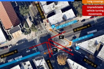
The Broadway Bridge corridor — counted as the 10 blocks from West 218th to West 228th streets — is clearly a dangerous place. In the last five years (from December 2016 until this month) there have been nearly 300 crashes, injuring 11 cyclists, 31 pedestrians and 78 motorists, according to Crashmapper. That’s more than one crash every week.

With stop lights only at 220th and 225th streets, pedestrians face perilous crossings, as a map of those crashes (above) shows. At 225th, below the 1 train, westbound traffic from 225th turns left onto Broadway to go over the bridge, creating potential conflicts with pedestrians trying to access the bus stop on the west side of the street.

The next signalized crossing is at 220th Street, the entrance to the Allen Pavilion — and, in fact, it is a dangerous “signalized sidewalk” (see above), a non-ADA-compliant arrangement that has led to at least one traffic death elsewhere in the city.

“I expect to see someone crash every time I cross the bridge,” said LeGrande. “I know someone will get killed because there is scarcely space for non-car users to cross the bridge when both sides are open — when they close down sides, these travelers attempt to cross in the roadbed where injury is very likely.”
Indeed, on a recent day an individual could be seen crossing Broadway by walking in the bridge roadway:

“Major bridge projects are not undertaken lightly,” said DOT spokesman Vin Barone. “Not only is this a moveable bridge, it is one of the only such bridges in country with a subway line running across it as well. In this case, our work will involve extensive repairs to the bridge structure, as well as its mechanical and electrical components to keep it operating safely for the next half a century.”
Per Barone, the project’s long timeline owes to the complexity replacing the the bridge span and rehabilitating the rest of the structure while keeping it open for the subway and the bus lines that move about 20,000 riders a day, plus other traffic. Other complications come from the waterway infrastructure and MTA facilities at the site. He said that the DOT has received only two complaints about the construction, both relating to debris. “We are excited to share our plans for bike connections next year,” he added.
Lyle Blackwood, the DOT’s community coordinator for the area, told the community board transportation committee that the project has a liaison on site “pretty much every day” and that “major construction still hasn’t started.”
So one wonders, how much less safe will the Broadway Bridge get?
