Public Plazas: A Tale of Two Cities

The city’s current model for streetscape improvements leaves residential communities, especially the less-affluent ones, out in the cold because good public space is only created when the city can find a partner to cover the insurance and can be sure of a decent return on investment.
That’s why, for example, a decade-long effort to beautify two decrepit Bronx roadways — streets that form the gateway to a $50-million library center in the Fordham neighborhood — fell apart. The city didn’t want to maintain the proposed improvements — and its “concession” model was unworkable for two residential streets that don’t generate income.
The story of the failed project is an example of priorities gone awry in one of the wealthiest cities in the world.
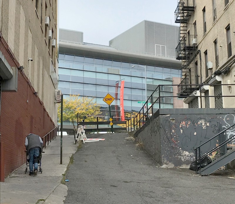
In 2001, the Fordham Bedford Housing Corporation wanted to redesign Coles Lane and Poe Place in anticipation of the opening of the new library on E. Kingsbridge Road. Coles Lane is a narrow, dead-end street that runs from Bainbridge Avenue to a flight of stairs that open up in front of the library. Poe Place — named after Edgar Allan Poe — is a dead-end street that’s perpendicular to Coles. Both need serious work — and the project was important to local organizers because the streets are popular routes for students and residents making their way to East Kingsbridge and the glistening new public edifice.

The corporation partnered with an architect from City College, who designed an attractive, green, well-lit, handicapped-accessible public space that complimented the library. The plan won support from the DOT’s then-Bronx commissioner, Joe Palmieri, and local electeds including Jose Rivera and Richie Torres. It even won a $750,000 grant from the Department of Design and Construction to cover the initial construction.
But the project died when DOT insisted that the Fordham Bedford Housing Corporation cover the maintenance of the plaza and, most onerously, the cost of insurance.
That can’t be emphasized enough: The city policy would have required a non-profit housing corporation to assume the responsibility and the risk over a much-needed public space.
So instead of getting a community asset, Bronx residents got the shaft.
Yes, DOT and the Department of Sanitation repaired the concrete and the steps, hauled out the trash, and cut the grass, but that was that. The library’s glass walled reading rooms still look out into a barren, concrete slab.
The city does have one work-around: On plazas in low-income areas, the DOT contracts maintenance and operations to The Horticulture Society of New York, which carries insurance. But the city still requires commercial activity to justify the creation of public space; Coles Lane and Poe Place are just residential streets.

The roots of this Catch-22 go back to the Bloomberg Administration, which, in a rush to open the Flatiron Plaza, settled on a concession model for maintaining public space. Under this approach, public space is perceived as a commodity that generates income rather than a public good. Today’s DOT has continued this approach — and in fact added new insurance requirements two years ago that were so onerous that the business improvement districts balked. Trying to make the maintenance agreement more palatable, Business Improvement Districts asked the DOT to cover liability insurance, as the Parks Department does for its partners, but DOT said no.
The BIDs have managed to negotiate a boiler plate insurance clause that works, for now.
Smaller BIDs and The HORT, which works under the same contract, are concerned about future liability. One or two falls in a plaza and the cost of insurance could become untenable. These agreements still leave less-affluent, residential areas with no options.
In the case of Coles Lane, one former DOT official lamented that the agency “really wanted to do something, but we just couldn’t find a reliable community partner.”
That’s ridiculous. Fordham Bedford Housing Corporation is a major neighborhood stakeholder that manages over 70 low-income properties in the area. Just because it couldn’t take on maintenance and liability insurance doesn’t mean DOT did not have a willing partner. Indeed, if DOT really wanted to transform this space, it could have.
All it would have required is taking a page from a playbook in Seattle, where on projects less than $25,000, the local DOT provides a stipend to community maintenance partners to cover insurance. On larger capital projects, when a portion of the roadbed is converted to pedestrian space, Seattle considers that space a city asset and not only covers the liability insurance, but maintains it as well.
Perhaps instead of sticking with a plan that favors commerce and undervalues community, it’s time for DOT to consider a new way of maintaining public space.
Janet Liff is co-founder of the Neighborhood Improvement Project.
