Imagining a New Atlantic Avenue for de Blasio’s New York

Atlantic Avenue is one of New York’s most prominent streets, and in most respects, it is completely broken.
Stretching more than ten miles, Atlantic cuts through several neighborhoods in Brooklyn and Queens while functioning mainly as an urban highway for private motorists and truckers making their way east, toward the Van Wyck and Long Island, or west, to the Brooklyn Queens Expressway.
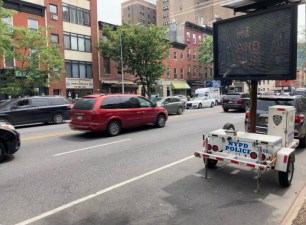
It is plagued with constant, speeding traffic. The avenue’s wide, highway-like conditions induce drivers to floor it, and as a result Atlantic is one of the most dangerous streets in New York City. When Council Member Steve Levin took a speed gun out to Atlantic, he found 88 percent of drivers were going more than 10 miles per hour over the limit. From 2008 to 2012, 25 people were killed on the 7.6-mile stretch of Atlantic between Furman Street in Brooklyn Heights and 76th Street in Woodhaven.
When the city announced that Atlantic would become the first street in the “arterial slow zone” program, with a 25 mph speed limit and re-timed traffic signals, it was welcome news. Atlantic is the kind of monster that has to be tamed if the de Blasio administration is going to achieve its Vision Zero street safety goals, and the new speed limit is a good first step.
In the long-run, though, Atlantic Avenue and the many other city streets like it will need much more comprehensive changes to not only eliminate traffic deaths, but also accommodate the economic growth and housing construction goals that City Hall is after.
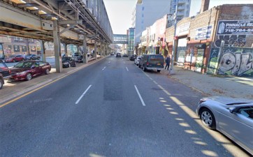
Today, much of Atlantic Avenue is an eyesore, especially along the stretch east of Flatbush Avenue. It’s basically an unsightly speedway, and land values along the eastern portion of Atlantic have historically been depressed. Empty lots sit beside carwashes and parking lots. Grassy weeds poke up through a decrepit median. Some portions fall under the shadow of elevated train tracks — the Atlantic Branch of the Long Island Rail Road, which otherwise runs below ground.
Does it have to be this way? Can’t we imagine an Atlantic Avenue that is an asset to the neighborhoods which surround it, rather than a challenge to work around?

At a time when development opportunities near transit are increasingly scarce, underdeveloped Atlantic Avenue represents a golden opportunity for new transit-oriented housing and jobs. The A and C train run along nearby Fulton Street, and the Long Island Rail Road has two stations along Atlantic before hitting the transit hub and Air Train at Jamaica Station. But the street’s aesthetics and lack of any public realm will make attracting new, quality development a challenge.
Meanwhile, rapid changes are transforming the neighborhoods flanking Atlantic, even as much of Atlantic itself remains depressed. The Barclays Center and Atlantic Yards are just the most visible of the development changes that are spreading eastward. The Franklin Avenue corridor is attracting new investment, including a redeveloped commercial building at 1000 Dean Street that will host “creative offices and studios” anchored by a ground floor “food and beer hall.”
Further east, city planners are thinking of opportunities for new jobs and better public space in East New York. The neighborhood is the focus of an effort by the city and federal governments that seeks to capitalize on the transit infrastructure and industrial land near Broadway Junction. The plan envisions new public plazas, commercial development, and a stronger industrial core — and Atlantic Avenue is in the middle of it all.
“In ten years time we want to see a completely different Atlantic Avenue,” Brooklyn Borough President Eric Adams recently told me, calling Atlantic a “hidden gem.”
Adams thinks there is a “great opportunity” for new development and that some areas of Atlantic could be up-zoned. “I think people have dipped their toes in the water and realized the water is not cold, it is very warm.” He envisions new hotels near the Nostrand Avenue stop on Long Island Rail Road, and mid-rise apartments with retail below, complete with a “restaurant row.” In East New York, his administration hopes for an industrial revival, leading to more jobs and activity.

Atlantic Avenue has inspired grand hopes in the past, hopes that ultimately went unrealized because of the very nature of the street — its highway-like character, the elevated train tracks, and dismal public realm. When street-level Long Island Rail Road tracks were removed from the median and the sidewalks were paved in the early 20th century, it was hoped that Atlantic would become another great street, lined with homes and businesses. Instead, according to a real estate publication at the time, “the avenue enhanced its fame only to the extent of becoming a fine thoroughfare for vehicles,” with the streetscape relegated to a future of “garages and factories.”
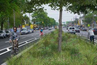
If Atlantic is to have a different future, if it is to become a great urban street, an ambitious redesign will be necessary. The “arterial slow zone” treatment, with lower speed limits, retimed signals, and widened medians, should be only the first step.
For a more thorough overhaul, the closest analogy in New York so far might be the new pedestrian space and bike lanes in the middle of Allen Street, a wide, two-way street on the Lower East Side. The complete streets overhaul of First and Second avenues also provides a glimpse of what’s possible when street space is shifted from cars and trucks to transit, biking, and walking. But ultimately, Atlantic Avenue is bigger, more complex, and in need of more ambitious changes than any street NYC DOT has recently redesigned.

Outside New York, one city to look to is Paris, where nearly every wide boulevard now has a separated bus lane that may also be used by cyclists, and many of the most intimidating two-way streets have been completely rethought to prioritize walking, biking, and the public realm. As global transit expert Jarrett Walker notes, “Name your favorite Paris boulevard, and it probably has bus lanes now.”
On some stretches of Atlantic, the middle of the street presents a major opportunity. “I love parts of Broadway on the Upper West Side,” said Josef Szende of the Atlantic Avenue Business Improvement District, which represents the western end of Atlantic, from Flatbush Avenue to the East River. “It’s broken down with a beautiful mall in the middle with planted trees, and it’s amazing.” Szende notes that his stretch of Atlantic doesn’t have the width to support this type of treatment, but that the eastern portion of Atlantic does afford the room.
NYC DOT’s stated policy for roadway reconstructions [PDF] is that “Excess width should be reallocated to provide walking, transit, and bicycling facilities, public open space, green cover, and/or stormwater source control measures.”
Other measures like protected bike lanes or dedicated bus lanes have worked to calm traffic and improve mobility on New York City streets. Currently, no buses run down Atlantic between Washington Street and Pennsylvania Avenue, though this area is served by the A and C lines two blocks north on Fulton and by the LIRR stations at Nostrand and East New York. East of Pennsylvania Avenue, new bus lanes could improve speeds on the Q24 while calming traffic and increasing economic activity.

A dedicated bikeway could be constructed underneath the elevated railroad tracks between Rogers Avenue and Howard Avenue. Currently the space is underutilized as a left turn lane. East of Pennsylvania Avenue, a new bus lane could also be used for bicycles, like on the wide streets of Paris.
Changing the look, feel, and function of Atlantic Avenue will not be easy. It is Brooklyn’s only east-west truck route, and any changes to street widths will have to take this into consideration. The elevated train viaduct is an obstacle, especially at the points where the tracks dive underground. Atlantic’s travel lanes come right up to the concrete walls that demark the trench. At the intersection with East New York Avenue, the roadway itself is elevated as it traverses the train tracks below.
With a thoughtful redesign, Atlantic could be transformed from the dangerous, unsightly mess that it is today into a truly great urban street. Such a redesign may be ambitious, but with a new mayor who’s brought ambitious street safety goals to City Hall, now is the time to think big about fixing New York’s most problematic streets.


