What Might “Brooklyn Bridge Beach” Mean for the East Side Greenway?

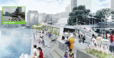
This morning, Manhattan Borough President Scott Stringer and City Council Speaker Christine Quinn announced that collectively, they had dedicated $7 million in capital funds to build what’s being called Brooklyn Bridge Beach. The aim of the new site beneath the iconic span is to attract New Yorkers to the East River waterfront and blunt the impact of storm surges.
Along with other projects on the East River, the beach could contribute to a high-quality, continuous greenway. But even as individual projects like the hypothetical beach gather momentum, planning for an East Side complement to the Hudson River Greenway remains scattered among a constellation of agencies and projects.
The beach is the first project to receive funding among the recommendations in the Blueway Plan, a vision for the waterfront between 38th Street and the Brooklyn Bridge released by Stringer and Assembly Member Brian Kavanagh in February. (The plan’s pricey highlight is a bridge deck over the FDR Drive near 14th Street that would improve access to East River Park and eliminate a pinch point in the greenway route.)
In February, Stringer said he was committing $3.5 million in capital funds to the construction of marshland along the riverfront; Quinn’s beach announcement signals the arrival of matching capital funds from the City Council, and Stringer hinted that more money could be on its way. “This is now money that we can leverage with the state and federal government,” he said.
Despite the commitment of funds, there are still important details missing from the proposal for the 11,000 square-foot beach. Conceptual renderings were produced for the Blueway Plan by WXY architecture + urban design, but the proposal does not include a more developed design. There is no timeline for completion of the project, nor is there an estimate of how much it will cost. And it remains to be seen whether the beach project would bring significant upgrades to the East River Greenway, which currently runs underneath the FDR Drive at this location.
“I’m excited that the new plans include a bigger esplanade with seating,” Quinn said, “and lit walkways, which is great to make sure this area can get used more.” Gesturing at the accumulation of sand, debris, and garbage along the river, Quinn added: “You have a natural opportunity to build a beach here.”
The mayor’s office was notably absent from today’s announcement. Mayor Bloomberg’s proposal for “Seaport City,” a landfill development on the east side, is adjacent to the Brooklyn Bridge Beach site. When asked today how the beach might be affected by the mayor’s proposal, Stringer dodged the question, simply saying that elected officials are working together.
Moving north, a number of agencies are involved in planning the East River waterfront. NYC EDC is working on esplanade improvements from the Battery to Montgomery Street, and the Parks Department is spearheading a new park at Pier 42 and upgrades in East River Park. North of the Blueway Plan area, EDC is leading a planning process that promises to plug the East River Greenway gap from 38th Street to 60th Street, including a land swap deal with the United Nations.
The United Nations Development Corporation has to get things started through the city’s land use review process, or ULURP, which would kick off the land swap and a transfer of funds that would allow the city to build a section of the East River esplanade, Council Member Dan Garodnick told Streetsblog. “I think we should start this ULURP process as soon as possible,” Garodnick said. “As far as I’m concerned, we should move forward. It’s an important part of connecting our East Side greenway.”
The first new section of the greenway on tap for Garodnick’s district is the rehabilitation of Waterside Pier, a $13 million project funded by Con Edison to open riverfront access between 38th and 41st Streets. Garodnick said the city is right now determining the viability of repair versus replacement of the pier before bidding out contracts for the work.
“We’re working together to try to create a seamless connection. You’ve gotta take it piece by piece,” said Garodnick, who also announced this morning that he is dedicating $1 million in capital funds to a kayak launch and fishing access point at Stuyvesant Cove near 20th Street.
Other projects are also on the horizon, Kavanagh said, with some as small as improved lighting beneath the FDR Drive at 34th Street or coordination with DOT and other agencies to ensure that public works in the area advance the goal of filling in greenway connections. The lease for the Skyport parking garage at 23rd Street is set to expire in 2015. Kavanagh said there might be an opportunity for new park space there, which could open the door for further greenway improvements at that location.
Elected officials at today’s announcement repeatedly invoked greenways and parks along the Hudson River and the Brooklyn side of the East River as models where piecemeal progress has led to large-scale improvements. “Don’t wait until you have every last dollar. If you’ve got a pot of money that can do one part of the park, do it,” Quinn said.
“The goal with both the Blueway and the greenway is to create continuous access,” Kavanagh told Streetsblog. “The West Side is one of the busiest pathways in the country. I think you’d expect something similar here.”
