EDC: Phased East River Greenway Gaps Set to Be Filled by 2024

For years, the Hudson River Greenway has been the star of Manhattan’s greenway network, while usage of its East River sibling has been damped by a deteriorating pathway and gaps in the route. Now, with a renewed focus on the East Side waterfront, momentum is growing to complete the greenway, even though completion is more than a decade away.
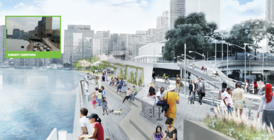
One of the most important projects is filling the greenway’s gap through Midtown, currently under study by the city’s Economic Development Corporation. Sixty percent of the $5 million planning process is funded by the United Nations Development Corporation, and the remainder is from federal, state, and city funds. A deal between the city and the United Nations, brokered by state legislation, will enable the construction of a continuous waterfront greenway from 38th Street to 60th Street.
Last night, EDC hosted a meeting with the project’s community working group, and revealed some new information about the timeline for completing the greenway’s missing link.
To extend the greenway north from 38th to 41st Streets, $13 million from Con Edison would restore a deteriorating structure that the utility used for fuel deliveries, known as Waterside Pier, along a roughly 45-foot wide route that would open to the public in 2015. The greenway past the United Nations campus would be the last to open, in 2024, and the design would have to address security concerns likely to restrict access to First Avenue.
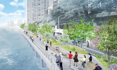
North of the United Nations, an existing dead-end waterfront esplanade is accessible by pedestrian bridge between 51st and 54th Streets, but the esplanade ends at 54th Street, where the FDR Drive is covered by apartment buildings until 58th Street. Along this section, EDC said support structures built in 2004 for a $139 million temporary roadway during FDR reconstruction could be reused for the esplanade — an idea that has idled for almost seven years. This section could open to the public in 2018.

A particular challenge for this project is that some of the East River’s deepest points — up to 100 feet — are very close to the Manhattan shoreline, with a lot of variability in the quality of bedrock, making construction on or beyond the river’s edge challenging and expensive.
This fall, EDC expects to present a preferred conceptual design to the working group, but last night EDC said that cyclists and pedestrians can expect a roomy greenway, with separate paths measuring at least 18 feet wide each.
In addition to the Con Ed funding for Waterside Pier, future phases of the project rely on $70 million from the United Nations as part of its acquisition of a section of the under-used Robert Moses Playground between 41st and 42nd Streets. Once UN offices move to the former playground site, the city-owned One and Two United Nations Plaza buildings would be put up for sale, and those revenues used to fund remaining construction.


