DOT Plans Safer St. Nick @ Amsterdam, With More Uptown Action to Come
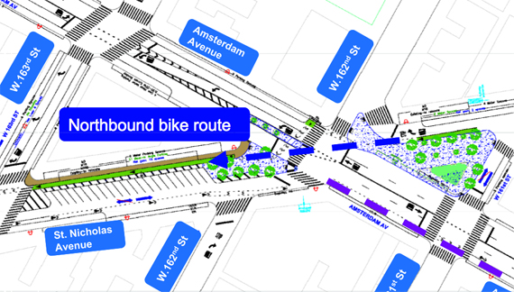
 Northbound cyclists on St. Nicholas at Amsterdam will have to negotiate a dogleg to reach the parking-protected lane. The southbound lane, at left, will be opposite a row of back-in angled parking. The speckled blue areas indicate new pedestrian space.
At a Monday night meeting with the transportation committee of
Manhattan Community Board 12, DOT rolled out a slew of much-needed
street improvements for Washington Heights and Inwood. Several are
still in the preliminary stage, but one major
intersection in the Heights is slated for an overhaul this fall.
The
crossing of St. Nicholas and Amsterdam Avenues, at W. 162nd Street, is
a hub of neighborhood activity, with access to the C train, four bus
lines, a grocery store and other retailers, as well as the Morris-Jumel
Mansion. It’s also a confusing, hazardous mess. From 2006 to 2009,
according to DOT, 23 pedestrians were injured there, while CrashStat shows scores of collisions and one pedestrian fatality between 1995 and 2005.
DOT
plans to clean up the area [PDF], replacing asphalt with green space,
shortening crosswalks, adding a protected bike lane segment, shifting
bus boarding areas, and improving commercial loading access.
Specifically, an existing Greenstreets triangle at W. 161st Street will be expanded into what are now auto lanes, and will stretch to W. 162nd Street. Northbound cyclists in the adjacent bike lane on St. Nicholas will have to contend with only one lane of drivers between W. 160th and W. 162nd. After a dogleg through the intersection, the lane picks up on the north side of 162nd as a parking-protected segment for one block. As Brad Conover of Inwood and Washington Heights Livable Streets points out, while southbound cyclists should benefit from the replacement of northbound car traffic with back-in angled parking on the 162-163 block, only northbound cyclists will have a protected bike lane.
"I am happy that DOT is redesigning this dangerous intersection and is including a protected lane," Conover told Streetsblog, "but my preference would be for protected bike lanes running north and south for the entire length of either St. Nick or Amsterdam so that a biker could ride safely from Inwood or Washington Heights to the Upper West Side or Central Park."
As for pedestrian amenities, the aforementioned swath of expanded green space will include a bus stop. And two additional new spaces are planned: a Greenstreets triangle north of W. 162nd and a pedestrian refuge in the center of Amsterdam, also on the north side the intersection. St. Nicholas will also be resurfaced from W. 155th to W. 168th, making for a smoother ride for cyclists and bus riders.
Up in Inwood, the results of the Sherman Creek traffic study are in [PDF]. Conclusion: Inwood is flooded with auto traffic (particularly around the "free" University Heights bridge) and is a dangerous place to walk. The study contains recommendations for improvements to many neighborhood intersections, but since they are expected to be revised we’ll forgo breaking them down for now. One corridor to keep an especially close eye on is Dyckman Street, where advocates hope that any overhaul will include a separated bike lane connecting east- and west-side Greenways — infrastructure that IWHLS members believe would spark a virtuous cycle in Upper Manhattan.
"The ‘corridor treatment’ for Dyckman Street from Riverside Drive to the Harlem River Drive will (I’m hoping) build momentum for a north-south bike lane," says Jonathan Rabinowitz. "Vigorous advocacy and the help of real-world examples in our own neighborhood will lead to more improvements and a safer Washington Heights and Inwood."
