Detailed Reports on 135 Safe Routes to School Plans
The DOT has some traffic plan porn for you today. Starting with P.S. 1 in Manhattan on Catherine Street, where they found a school bus parking on the narrow sidewalk near the school, they have detailed reports including pictures and proposed re-designs of the streets for all 135 schools included in the initial wave of Safe Routes to Schools. Dig in everyone and send us what you think of a school that you know about.
(Unfortunately, I can’t figure out how to capture an image from what seem to be extremely secure PDF files – more later)
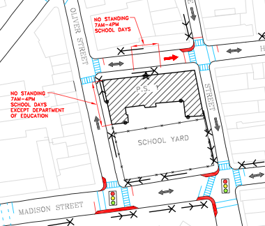
Update: 8:30pm. On a different computer, I can now extract the images using the old Mac Apple key/Shift/4 move). Here is the PS 1 Manhattan map of existing infrastructure and proposed improvements. Note a number of new sidewalk bump-outs and neck downs (Red areas) and some "no standing" signs in front and on the side of the school.
No doubt much more to come from Streetsblog and it’s readers on all of this.